This dialog box allows you to thin data at import time. For large data sets (like LiDAR), it may be impossible to read all available points without running out of memory. If desired, you can create a list of regions and thin points differently in each region. Regions can be:
Rectangles
Corridors
Polygons
A Default region always exists; this region includes all points.
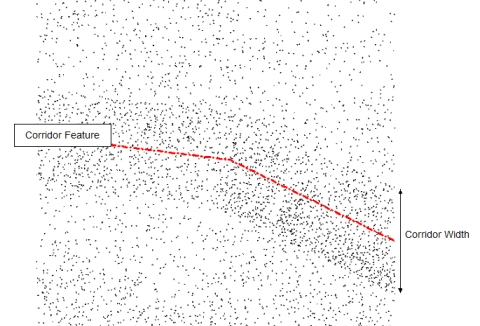
For example you might create a Corridor region based on a proposed road alignment. If the Corridor region is set to read all points (skip 0), and the Default region (last on the list) is set to skip all points, then data will only be imported inside the corridor (your area of interest). Alternately, if you set the Default region to skip 9, then 90% of points outside the corridor will be discarded (10% resolution); see image below.
Points thinned by Corridor
Regions (list)
Use the associated buttons (descirbed below) to create a list of regions.
Add (button)
Opens the Filtering Region dialog box so you can define a new region.
Modify (button)
Opens the Filtering Region dialog box so you can modify the selected region.
Remove (button)
Removes the selected region.
Shift Up/Down (buttons)
Moves the selected region up/down in the list. The order is important! Points are thinned according to the first region which contains them.
Point Resolution
Control thinning for the selected region.
# Skipped (slider and edit box)
Use these controls to define the number of points skipped after a point is read. Examples:
# Skipped = 0 all points are included (100%)
# Skipped = 1 one is read and one is skipped (50%)
# Skipped = 9 one is read and 9 are skipped (10%)
All (check box)
Set this check box to skip all points in the region (this disables the # Skipped controls.