ASCII Coordinate Files
The Coordinate File Format is an ASCII file containing XYZ information for the origional ground and design surfaces. It can be used for exporting coordinate information to a total station for staking (blue-topping).
Fields
Every point on the cross section is saved as a line in the file.
The following fields can be included in the output:
PStation
P-line station.
LStation
P-line station.
Flag
-OG for topo (origional ground).
- STRIP for stripped surface
-SG for subgrade
-SRF1 for 1st surface above subgrade
-SRF2 for 2nd surface above subgrade
-SRF3 for 3rd surface above subgrade
X, Y, Z,
coordinate of the point.
Code
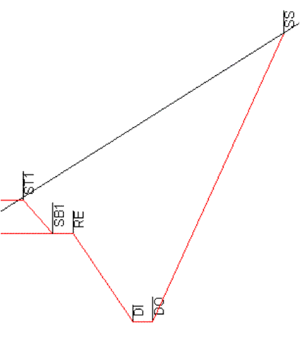
template code points (see figure below).
Figure 1. Subgrade and Surface Point Codes
H. Offset
Horizontal offset from centerline (l-line)
V. Offset
Vertical offset from centerline (l-line)
Sequence Number
A sequential number for each cross section.
Static Text
Any constant static text can be included in a field.
Example1: All Surfaces Export
0.00,0.00,SG,15.60,-6.85,100.00,SSL,-15.84,0.35
0.00,0.00,SG,12.99,-5.70,97.15,DIL,-12.99,-2.50
0.00,0.00,SG,10.26,-4.50,99.15,REL,-10.00,-0.50
0.00,0.00,SG,1.11,-0.47,99.65,CL,0.00,0.00
0.00,0.00,SG,-8.05,3.56,99.15,RER,10.00,-0.50
0.00,0.00,SG,-10.78,4.76,97.15,-,12.99,-2.50
0.00,0.00,SG,-13.39,5.91,100.00,SSR,15.84,0.35
0.00,0.00,SRF1,10.26,-4.50,99.15,SB1L,-10.00,-0.50
0.00,0.00,SRF1,8.73,-3.82,99.98,ST1L,-8.32,0.33
0.00,0.00,SRF1,1.11,-0.47,100.40,CL,0.00,0.75
0.00,0.00,SRF1,-6.51,2.88,99.98,ST1R,8.32,0.33
Example2: Topo Export (B.C. MOT -- MTS format)
X,1,OG,0.00,-66.20,496.08
X,2,OG,0.00,-66.16,496.05
X,3,OG,0.00,-64.85,495.22
X,4,OG,0.00,-63.18,493.37
X,5,OG,0.00,-62.28,492.74
X,6,OG,0.00,-60.84,490.59
X,7,OG,0.00,-59.15,488.77
X,8,OG,0.00,-58.33,488.27
X,9,OG,0.00,-57.05,488.19
X,10,OG,0.00,-54.01,487.89
X,11,OG,0.00,-53.85,487.87
X,12,OG,0.00,-53.77,487.87
Note:
field 1 = Static text = X
field 2 = sequence number