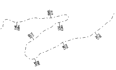
Some label categories allow you to control the spacing of labels by entering a Min. Spacing. If selected, labels will only be displayed if the Min. Spacing between successive labels is greater than the specified distance. Entering a Min. Spacing of 0 will cause all labels to be displayed. If you explicitly enable or disable an individual label, the minimum spacing will be ignored for that point. The following example shows a traverse with the Min. Spacing for Elevation and Station labels set to 200.0.
Figure 1. Using Minimum Spacing with Elevation and Station Labels
To Edit Feature Labels:
Switch to Edit Label Mode, then double click on the specific feature label you wish to edit. The Label Selection and Formatting Dialog will pop up allowing you to make changes to the display text and positioning.