Import ASCII Codes dialog
This dialog allows you to set up how feature codes are to be interpreted. Using this effectively will allow you to automate the drafting of field survey files. You can specify to draw a certain symbol at a particular point code, or draw particular features with a certain linetype.
Note: If the field you wish to change is uneditable, that is because the current setting of the Feature Detection Method doesn't allow editing of that particular column.
Codes
This area of the dialog lists all the codes you have set up. The DEFAULT code must always exist and is the first code in the list. You can add and remove codes using the Add / Remove buttons. Use the Shift Up/Shift Down buttons to organize the codes.
Code Properties
This area of the dialog displays the properties of the currently selected code in the Codes list.
Code Name
This field will be the same text string that is in your ASCII file. The program will use the DEFAULT code for any codes that don't exist in the code list.
Wild Card Matching is allowed in the code name. E.g.
* Matches any number of characters. You can use the asterisk (*) anywhere in a character string.
? Matches a single alphabet in a specific position.
For example the wild card string ?ABC* will match:
1ABC
1ABCXYZ
aABCDE
It will not match
AB
1AB2
Type
Type can be either Point or Polyline. Point type will always create an individual feature for each coordinate. Polyline type will chain together same codes to create one feature.
NOTE: if the Type field is disabled you may have to change the Feature Detection Method (see Structure tab - Features button) . Some Feature Detection method supports only one type of feature e.g. the " Each Coordinate is a Feature" method supports only Points.
Feature Creation
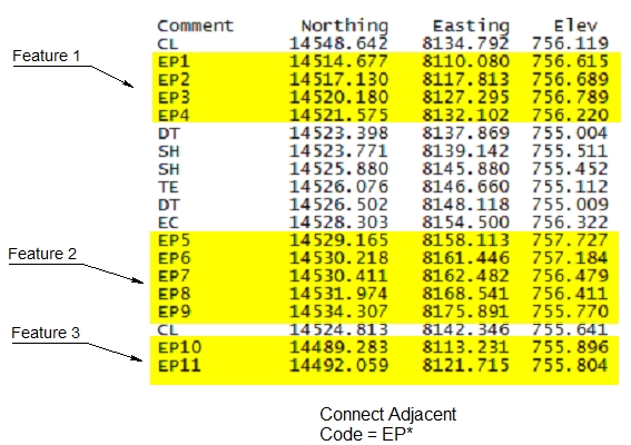
Connect Adjacent - will create a feature made up of sequential records matching the code specification.
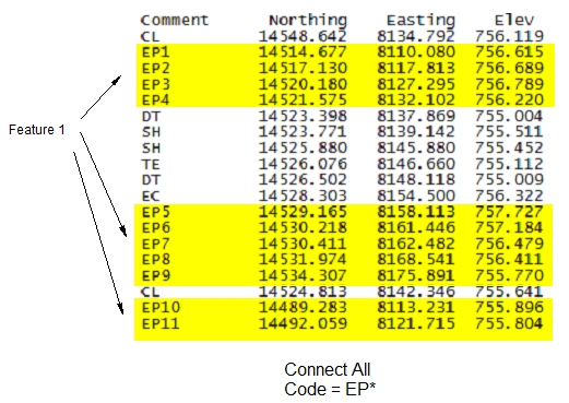
Connect All - will create a feature consisting of all the records matching the code specification.
The following examples illustrate these methods:
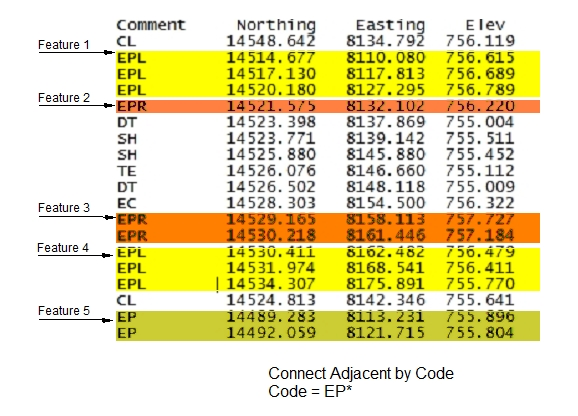
The next 2 options apply only when a wild card code is used in the code (eg. ROAD* or DITCH?? or DEFAULT).
Connect Adjacent by Code - will create a feature made up of sequential records with exactly the same code. (as apposed to Connect Adjacent which will connect any points matching the wildcard).
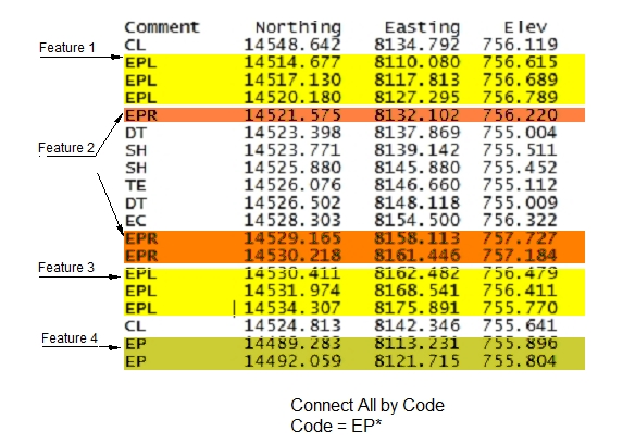
Connect All by Code - will create a feature made up of all the records with exactly the same code.
(as apposed Connect All which will connect any points matching the wildcard).
The following examples illustrate these methods:
Connected
Skip
Any records containing this code will not be imported into Terrain.
3D
Any features created from this code will have the Elevation property set. See the Feature Properties dialog for more information.
Breakline
Any features created from this code will have the Breakline property set. See the Feature Properties dialog for more information.
Include in Model
Any features created from this code will have the Modeled property set. See the Feature Properties dialog for more information.
Color
Set the color to use when creating features from this code.
The "+" button after the color allows you to create a custom color by entering an RGB triplet. See Custom Color dialog.
Line-type
Set the line-type to use when creating features from this code.
Symbol
Set the symbol to use when creating features from this code.
Hatch
Set the hatch-type to use when creating features from this code.