Live Maps
LiveMaps provides functions for importing georeferencded images and DEM data.
If your terrain is georeferenced, goto the Home Ribbon of the tool bar, press the “Import”button. LiveMaps will launch.
LiveMaps controls
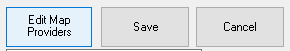
Edit Map Providers
configures the available map provider services.
Save
Saves the highlighted area of the map.
Cancel
Exits LiveMaps without saving anything.
LiveMaps Navigation
Zoom In
move closer
Zoom Out
move further away
Crop
select a screen subsection for export to Terrain
LiveMaps Provider Selection
Select Map Source (listbox)
choose on of the available map sources, the defaults are Google, Bing, and MapTiler
Map Type Radio Buttons
choose one of the three map styles
Satellite
satellite imagery
Street
street maps
Terrain
topographic imagery
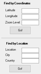
LiveMaps Search
Find by Coordinates
Latitude
enter latitude coordinates in degrees
Longitude
enter longitude coordinates in degrees
Zoom Level
relative zoom level
Find by Location
this service available for map services with activation keys
Location
enter a common geographic name (eg. Trafalgar Square)
City
enter name of the city
Country
enter name of the country
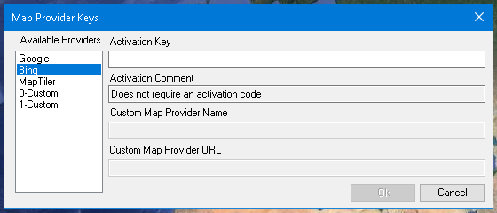
Edit Map Providers Dialog
Here you can configure the map service providers that LiveMaps can use
Available Providers (list box)
list of all the available map providers, clicking on one of the items in the list here will display the relevant infomation about that map provider
Activation Key
Enter the map provider's activation key here
Custom Map Provider
RoadEng supports the use of custom map providers, in the situation that you may have your own map imagery that you may wish to import into your RoadEng terrain. The limitation is that the map provider must be a Web Map Tile Service. The service must also support the Universal Transverse Mercator coordinate system. You will need a working understanding of URLs and how to write and format them correctly.
A given WMTS map provider will serve up map tiles of 256x256 pixels or 512x512 pixels in size. The Custom Map Provider feature only supports 256x256 at this time.
Custom Map Provider Name
Enter the name of your choice for this custom map provider
Custom Map Provider URL
Enter the URL for this custom map provider. The format of this url request is unique to every map provider
for example, this is the url for the US Geological Survey
https://basemap.nationalmap.gov/arcgis/rest/services/USGSImageryOnly/MapServer/WMTS/tile/1.0.0/USGSImageryOnly/default/GoogleMapsCompatible/{0}/{2}/{1}
The 3 parameters {0}/{2}/{1} correspond to the "zoom level", column, and row.
Some map service providers require a user access key or authentication code. The exact format for this is up to the individual provider, but it will look something like this:
https://wmts.domain.com/satellite/{0}/{1}/{2}/256/png8?ACCESS_ID=kUYbGW075lm_upXSE38-2
note the text in bold italics, this represents the accesskey (note that this is a made up example and does not correspond to any actual WMTS service)
Trouble-shooting the Custom Map Provider
If this url is configured correctly and the map service is enabled and available to you, it should retrieve and display map tiles within Live Maps the same as the default map providers like Google and Bing Maps.
If you select your custom map provider and LiveMaps displays "Sorry, Image not found" or a blank view, the most likely reason is that the url is not formatted correctly.
If you select your custom map provider and it does seem to draw map tiles, but they look like a mixed-up jigsaw puzzle. This is probably because the row and column wild cards are reversed. Update your customUrl, and swap the {1} and {2}
If the custom map provider works in some areas of the world, and not others, most likely the map provider only has imagery available for certain regions of the world.
OK (button)
Closes the dialog and saves all changes
Cancel (button)
Closes the dialog without saving any changes