Feature Coordinates dialog
The dialog box supports two methods of entry: Survey Format and Coordinate Format. In Survey Format the underlying feature coordinates are calculated from azimuth, distance and slope shots. In Coordinate Format the x, y, z coordinates of each point are manipulated directly.
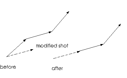
NOTE: In Survey format when a shot is changed the coordinates of the points after the shot are adjusted so that subsequent shots remain unchanged.
Figure 1. Modification of a Shot in Survey Format.
Curves are generated between the current and next points in Coordinate Format; the radius must be bigger than half the distance between points (chord distance). In Survey Format, the Curve Options button can be used to change the way the Azimuth and Distance fields are interpreted, see Curve Options button below.
If the Z coordinate or slope % is unavailable for editing the feature is a Draped feature.
Prev button
Decrements the current point. In Survey format the current point is at the end of the shot.
Next button
Advances the current point. In Survey format the current point is at the end of the shot.
Add button
Pressing the Add button creates a new point or shot (depending on format). In Coordinate format the new point (x=0,y=0,z=100) is added. In Survey format a new shot (Az=previous, Dist=100,Slope%=0) is added. This button is disabled in Coordinate Format if the current point is the beginning of a curve (radius defined).
Delete button
Deletes the current point or shot.
Current Point
Update List button
Updates list display with the data in the Current Point area. This occurs automatically on Prev, Next or Add.
Options
Survey Format check box
Change between Survey Format (azimuth, distance, slope edit) and Coordinate Format (x, y, z edit).
Curves check box
Enable curves editing; Radius edit box and Right/Left controls become visible. If a feature has curves the Curves check box is disabled and checked (you can't turn it off). If the Enhanced Mapping and Drafting functional group is disabled then the Curves check box is disabled and unchecked (you can't turn it on).
Lat/Lon check box
You need to set a grid coordinate system (such as UTM) for this option to be enabled. Geographic coordinates input in latitude/longitude will be reprojected to the grid coordinate system.
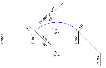
Curve Options button
In Survey Format, this button can be used to change the way the Azimuth and Distance fields are interpreted when a radius is defined. The Azimuth and Distance field headings adjust as soon as you enter a radius to indicate which format you are using. In addition, the list display appends a character after the azimuth and distance items to indicate what they represent:
Curve Azimuth options
|
Suffix
|
Header
|
Description
|
|
none
|
Chord Az
|
Azimuth along Chord (BC=begin curve to EC=end curve)
|
|
T
|
Tangent Az
|
Azimuth along tangent at BC
|
|
R
|
Radius Az
|
Azimuth along radius (BC to center)
|
|
C
|
Center Az
|
Azimuth along radius (center to BC)
|
Curve Distance options
|
Suffix
|
Header
|
Description
|
|
none
|
Chord Dist
|
Distance along Chord (BC=begin curve to EC=end curve)
|
|
A
|
Arc Az
|
Distance along arc
|
|
D
|
Incl Deg
|
Included angle or Delta (degrees)
|
Figure 2. Applying Curve Options