Importing Unit Survey
The unit survey format reads raw survey shot data. It is very useful for downloading general survey information such as radial surveys or digital data collected with a Laser Gun. The file contains foreshots, backshots and side shots.
The coordinates of each leg of the traverse are calculated based on the azimuth, inclination and distance. When a traverse contains loops, adjustments for closure are not automatic. Foreshots, backshots and multiple shots for the same leg of a traverse are averaged.
Horizontal angles can be entered as either absolute angles or turned angles. Turned angles are measured from a backsight (type BS) with match (but reversed) point numbers. An example of a turning angle survey is included below.
The file is in ASCII format with fields delimited by commas.
Each record contains the following fields:
|
SURVEY IDENTIFIER
|
Maximum of 8 characters or numbers uniquely identifying the name of the traverse. The characters should be a valid DOS file name.
|
|
MEASUREMENT TYPE
|
One of SR,FS,BS or SD.
SR = Start reference
NOTE: SR Applies to the shot following. For an FS the 'From' coordinate is set. For a BS then the 'To' coordinate is set.
FS = Foreshot
BS = Backshot
SD = Sideshot
|
For Measurement types FS, BS and SD the following fields are included in the record:
|
FROM,TO
|
From, To point indicators.
|
|
HORIZONTAL
MEASUREMENT
|
Azimuth - decimal degrees or D:M:S.
|
|
VERTICAL
MEASUREMENT
|
This field is optional for BS type records. Can be any one of the following (see File | Import Feature Set - Options).
Inclination Angle - Measured positive upwards, decimal degrees or D:M:S
Zenith Angle - decimal degrees or D:M:S
Slope %
Elevation
Elevation difference
|
|
DISTANCE
MEASUREMENT
|
Distance can be horizontal or slope and is assumed to match Softree project units. This field is optional for BS type records.
|
|
HI
|
Height of instrument
|
|
HT
|
Height of target
|
|
Code
|
Code identified with the "TO" point. Max 15 characters.
|
For Measurement types SR the following fields are included in the record:
|
X
|
Starting Easting (X coordinate)
|
|
Y
|
Starting Northing (Y coordinate)
|
|
Z
|
Starting Elevation (Z coordinate)
|
|
CODE
|
Starting code
|
Unit Survey Importing Procedure
1.Create a *.pol file using a spreadsheet or by transferring data from the Criterion using Laser Technology's download and conversion program. NOTE the file must be in ASCII format. Be sure to use the "Save As" menu in your spread sheet software to save the file as a comma (",") delimited ASCII file.
3.Select Unit Survey format.
4.Choose Options to select the formatting of the fields such as Zenith or Inclination etc.
5.Select *.pol file.
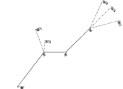
Example - absolute angles
TRAV1,SR,1420,2230,1311,BM1
TRAV1,BS,2,1,180:30:00,.356,120,0,0
TRAV1,FS,1,2,75:30:00,.356,120,0,0,TP2
TRAV1,SD,2,5,340:30:00,.12,67,0,0,SS2-5
TRAV1,SD,2,6,5:30:00,.12,33,0,0,SS2-6
TRAV1,FS,2,3,90:30:00,.256,60,0,0,TP3
TRAV1,FS,3,4,45:30:00,.12,93,0,0,TP4
TRAV1,SD,4,8,25:30:00,.12,85,0,0,SS4-8
TRAV1,SD,4,9,45:30:00,.12,85,0,0,SS4-9
TRAV1,SD,4,10,75:30:00,.12,85,0,0,SS4-10
Figure 1. Importing Unit Survey
Example - turned angles
Test,SR,5000,5000,100,Start
Test,BS,1,7,0,-6.35,223.44,5.03,2.5,Stn
Test,FS,1,2,238.39,-6.12,282.73,5.03,2.5,Stn
Test,BS,2,1,0,5.07,281.82,5.01,2.5,Stn
Test,FS,2,3,214.46,-0.82,282.72,5.01,2.5,Stn
Test,BS,3,2,0,-0.29,282.69,5.25,2.5,Stn
Test,FS,3,4,253.53,-0.47,246.88,5.25,2.5,Stn
Test,BS,4,3,0,-0.78,246.97,5.13,2.5,Stn
Test,FS,4,5,213.71,-0.29,161.22,5.13,2.5,Stn
Test,BS,5,4,0,-1.67,161.3,5.3,2.5,Stn
Test,FS,5,6,237.11,-0.06,270.57,5.3,2.5,Stn
Test,BS,6,5,0,-1.15,270.79,5.23,2.5,Stn
Test,FS,6,7,213.13,-0.16,278.01,5.23,2.5,Stn
Test,BS,7,6,0,-0.95,278.13,5.23,2.5,Stn
Test,FS,7,1,249.91,4.98,222.77,5.23,2.5,Stn